
The problem with the Dingle Peninsula as a day trip from Killarney is the word 'day'. You'll need one. You might need two. And there's a fair chance you'll be sitting in a pub in Dingle town at half six, watching the fishing boats come in, knowing the drive back is ninety minutes and not especially caring. Plan it properly, though, and a single long day is enough to do it right: the Connor Pass, Slea Head Drive, Gallarus Oratory, and Inch Beach on the way home, with time to eat and not feel rushed. This is how to do it.
Getting there: two routes, do them both
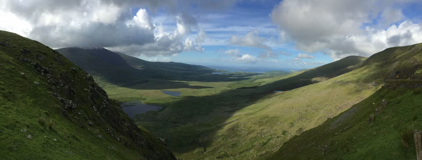
From Killarney, you have two options and the advice is simple: go one way, come back the other. The northern route via Tralee and the Connor Pass is the more dramatic of the two. Take the N22 from Killarney toward Tralee (about 30 kilometres), pick up the N86 through Tralee and then the village of Camp, and follow it west as the road starts climbing. You'll know when you're on the pass. The valley floor drops away behind you, the Atlantic opens up ahead, and on a clear day the whole of Dingle town appears below you like someone arranged it there specifically to make you stop the car. The drive from Killarney to Dingle via this route is around 90 kilometres and takes about an hour and twenty minutes. Allow more if the weather's interesting, which it probably will be.
The southern return route goes through Ventry, around the coast, back through Annascaul and Inch Beach, then east on the R561 through Castlemaine and Killorglin back to Killarney. About 80 kilometres, a little over an hour in normal traffic. By the time you use it you'll have done Slea Head Drive and Inch Beach from both directions, and the two routes between them cover most of what the peninsula has to offer from a car.
The Connor Pass
At 456 metres, the Connor Pass is the highest mountain pass open to road traffic in Ireland, though it doesn't announce that fact with any particular fanfare. The road through it is mostly single-track near the top, with passing places, and it can be genuinely narrow in summer when tourist camper vans meet farm vehicles going the other direction. Take it at a sensible pace and pull into the passing places early rather than waiting to see who blinks first.
The viewpoint at the summit layby is worth stopping at even if the clouds are low, because the clouds do strange and dramatic things at this altitude in Kerry and the visibility can change completely in ten minutes. On a clear day you have Dingle Bay to the south, the Brandon Mountain massif to the north, and the town directly below on the water's edge. It's a fair oul' view.
A note for larger vehicles: the approach from the Tralee side going west (downhill toward Dingle) is the easier direction. Coming from Dingle going east, the road steepens considerably near the top and some motorhomes have had a bad time of it. If you're in something wider than a typical car, go into Dingle on the Connor Pass and leave on the southern route through Annascaul. The signs also recommend this. The signs are right.
Dingle town
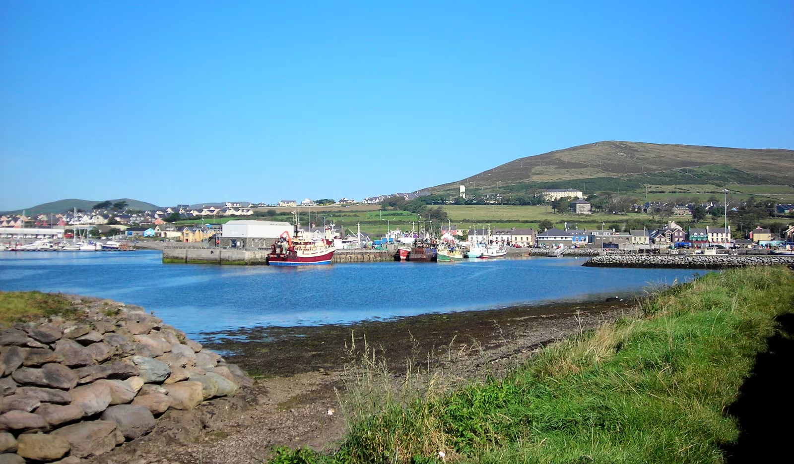
Dingle is a working fishing port and the largest town on the peninsula, with a population of around 2,000 people. It's in the Gaeltacht, which means Irish is the first language and the official placename on government signs is An Daingean, though the English version has been fighting that particular battle for decades and shows no signs of leaving.
The harbour is genuinely beautiful and genuinely functional. Fishing boats in, tourists out, a few cafes along the front where you can sit with a coffee and watch both happen. Out of the Blue on the Waterfront is one of the better seafood restaurants in Kerry (closed when the fish is bad, open when it isn't, cash-only, and the one place where being turned away is actually a good sign because it means you didn't plan ahead). John Benny's pub does food and has the kind of interior that took decades to accumulate. Dick Mack's on Green Street is half pub and half cobbler's workshop, because why not, and the craic there on a good evening is properly class.
Murphy's Ice Cream on Strand Street deserves its reputation. The sea salt variety uses Dingle Bay salt and tastes exactly like it sounds: sweet and sharp and a bit oceanic. Get a cone and walk down to the harbour. You will look like every other tourist doing exactly the same thing and it will be entirely worth it.
Fungie the dolphin, who became famous for living alone in Dingle harbour from 1983 and letting visitors swim alongside him, disappeared in October 2020. Boat trips still run from the harbour hoping to spot bottlenose dolphins in the bay. Some days they do.
Slea Head Drive
The Slea Head Drive is a 47-kilometre loop from Dingle town that goes west around the tip of the peninsula and back. Do it clockwise from Dingle, which keeps the sea on your left, and allow two to three hours with stops. You will stop more than you think.
The road runs through some of the oldest inhabited landscape in Ireland. The beehive huts at Fahan, a few kilometres past Ventry beach, are around 400 dry-stone corbelled structures scattered across the hillside above the sea. Most are Iron Age, some are early medieval, and they're remarkable mainly because they're still there and there are so many of them. There's a small admission charge at the access gate, and it's worth it. Stand inside one of the larger ones and consider the fact that people were living here before the Normans had landed in England. Then consider that the view hasn't changed much either.
Dunbeg promontory fort, just before the beehive huts on the drive, is an Iron Age coastal fort perched on a headland with the Atlantic on three sides. The cliffs below it have been eroding for centuries and parts of the fort have already gone into the sea. What's left is still impressive and a bit vertiginous.
Slea Head itself is the westernmost point on the mainland of Ireland, and the view from the roadside layby on a clear day takes in the Blasket Islands across the sound. The Great Blasket was permanently evacuated in 1953 when the remaining 22 islanders petitioned the Irish government for relocation, having been left without a priest or doctor for too long. The island is visible from the headland as a dark shape about five kilometres offshore, and you can take a seasonal ferry from Dunquin if you want to get closer. The Blasket Centre at Dunquin tells the evacuation story well and has a good cafe.
Gallarus Oratory
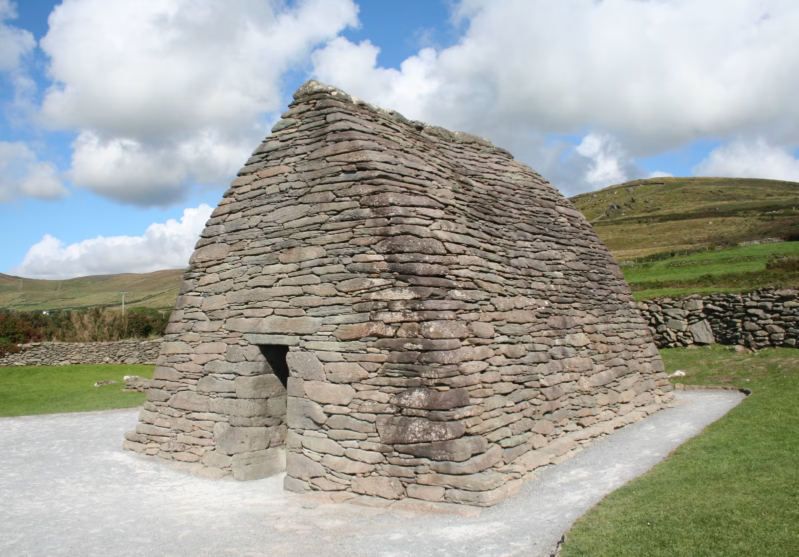
A short detour north off the Slea Head Drive near Ballintlea brings you to Gallarus Oratory, an early Christian church built in dry-stone corbelled masonry that is so precisely constructed it has remained waterproof for over a thousand years without any mortar. It's about the size of a single-car garage, shaped like an upturned boat, and it is one of the most complete early medieval buildings in Ireland.
There's a visitor centre on the road above with a car park and a small admission charge of around five euros. You can also see the oratory clearly from the road without paying, if that's your preference. Up close, though, the quality of the stonework is the point: each course of flat stone is slightly angled outward and down, so rainwater runs off rather than in, and the technique has held for roughly twelve centuries without any maintenance. If that doesn't make you feel slightly inadequate about your own DIY skills, nothing will.
Allow twenty minutes here, or an hour if you're the type who likes to sit quietly and think about time. Both are equally valid. Don't skip it on a tight schedule; it's only a five-minute detour and there's nothing else quite like it on the peninsula.
Inch Beach on the way home
The south route back to Killarney goes through Annascaul and past Inch Beach, a 4.8-kilometre spit of sand and dunes that reaches out into Castlemaine Harbour with the Iveragh Peninsula on the far side. It's a serious beach, wide and flat, popular with surfers and families and people who just want to stand in the wind for a few minutes before getting back in the car. The Atlantic gets to it properly, so the waves are consistent and the wind is usually doing something interesting.
Sam's Place at the car park end does food and hot drinks. It's informal, reliably good, and gets busy on weekends. The view from the beach looking back across toward the Ring of Kerry mountains is one of those that rewards standing still for a bit. If you've had enough driving, this is a good place to decompress before the last stretch back to Killarney.
From Inch Beach, the R561 takes you east through Castlemaine and then the N70 connects you back to Killorglin and south to Killarney. Around an hour from the beach to the town, depending on how much of Killorglin you get stuck behind on a Saturday afternoon (sometimes: a lot).
For the next day, Killarney itself has more than enough to keep you busy without leaving the national park. The national park guide covers what's worth your time in the 26,000 acres on the doorstep. And if you want another Kerry mountain road rather than a beach, the Gap of Dunloe is the classic alternative, much closer to Killarney town and a completely different landscape.
How long does the Dingle Peninsula day trip take from Killarney?
A full day trip covering the Connor Pass, Dingle town, Slea Head Drive, Gallarus Oratory, and Inch Beach takes around nine to ten hours including stops and meals. The total driving distance for the loop is approximately 220 kilometres. An early start from Killarney by half eight or nine allows you to be in Dingle for lunch, complete Slea Head Drive in the afternoon, and be back in Killarney by early evening. Allow more time if you plan to stop for a swim at Inch Beach or spend time at the Blasket Centre in Dunquin.
What is the best route from Killarney to Dingle?
The most scenic route is via the N22 to Tralee, then the N86 through Camp and over the Connor Pass into Dingle. This is approximately 90 kilometres and takes about an hour and twenty minutes. The alternative southern route via Castlemaine and Inch Beach is about ten kilometres shorter but significantly less dramatic. Most visitors do the loop, going in over the Connor Pass and returning via the south coast through Annascaul and Inch Beach, which covers more of the peninsula in one trip.
Is the Connor Pass safe to drive?
Yes, with care. The road is single-track near the summit with passing places, and it handles ordinary cars without difficulty. The main consideration is meeting larger vehicles coming the other way: pull into the passing places early and take your time. Large campervans and motorhomes are better approaching from the Tralee side going west, as the eastern ascent from Dingle is steeper and narrower. The pass is sometimes closed in winter after heavy snow but is open year-round in normal conditions.
What is Slea Head Drive?
Slea Head Drive is a 47-kilometre loop road from Dingle town that circles the western tip of the Dingle Peninsula. It passes Ventry Beach, the Iron Age Dunbeg fort, the beehive huts at Fahan, the Slea Head headland with views of the Blasket Islands, the Blasket Centre at Dunquin, and connects back to Dingle through Ballyferriter and past Gallarus Oratory. Driving it clockwise from Dingle is recommended, takes two to three hours with stops, and is generally considered one of the most scenic road circuits in Ireland.
Is Gallarus Oratory worth visiting?
Yes. Gallarus Oratory is a remarkably preserved early Christian church, likely built between the 8th and 10th centuries, constructed in dry-stone corbelled masonry with no mortar. It has remained watertight for over a thousand years. It is a five-minute detour off the Slea Head Drive near Ballintlea. There is a visitor centre with a small admission fee of around five euros, and the oratory is also partially visible from the road for free. It takes about twenty minutes to visit properly.
What is Inch Beach like?
Inch Beach is a 4.8-kilometre sand and dune spit on the south side of the Dingle Peninsula, at the entrance to Castlemaine Harbour. It faces across Dingle Bay toward the Iveragh Peninsula and the Ring of Kerry mountains. The beach is exposed to the Atlantic and has consistent surf. It is a popular swimming and surfing beach in summer. Sam's Place at the car park provides food and hot drinks. Inch Beach is on the southern return route from Dingle to Killarney via the R561 and N70, making it a natural stop on the way back.
For a full day in Kerry without driving, including jaunting cars, cycling the national park, and the boat to Innisfallen Island, the Killarney without a car guide covers everything reachable on foot or two wheels from Killarney town. And if the Ring of Kerry is also on your list, the local tips for driving the Ring are worth reading before you go: it's a different day and a different peninsula, and the two make a solid two-day Kerry itinerary between them.
Images: Slea Head panorama by Einaz80 (CC BY-SA 4.0, via Wikimedia Commons). Connor Pass by David Leip (CC BY 2.0, via Wikimedia Commons). Dingle Harbour by Jim Linwood (CC BY 2.0, via Wikimedia Commons). Gallarus Oratory by Ingo Mehling (CC BY-SA 3.0, via Wikimedia Commons).